
Measuring coastal erosion using robots
It might surprise you to know that we have relatively little information on the rate of coastal erosion at key spots along our shoreline. This is where community co-led design can help. There are ways we can direct outcomes to where it matters most to us.
Right now, our priority has to be on gathering our community’s wisdom and knowledge, so we can work out where to take action. This is why we invite you to join one of our workshops (see below)
As you can imagine, it would be premature to assume where to focus actions, before we know where it’s most valuable and most needed. Effort expended in coastal management without this critical step might be in the wrong palce … which is why community co-design is so essential. This can’t be known until your knowledge is used as the basis for decisions.
How will workshop information be used?
Let’s take coastal erosion as an example. Once we’ve run our workshops, we will have a better idea where coastal erosion processes are likely to be having the greatest impact. Is it even a problem? We actually don’t know – which is why we’ve just done baseline measurements in a few places.
One of the consequences of coastal erosion is rising insurance premiums. The Insurance Council of Australia, for example identifies nature loss as a key issue for insurability, adding ‘Australian insurers must take action to … accelerate the transition toward a … society that exists in harmony with nature’. About 83% of our homes are underinsured already.
The Insurance Council of Australia is saying that your insurance can be better protected using nature but the key word here is ‘society’. Nature-based solutions are impossible to achieve without community-led design. We are the only people qualified to inform decisions and make that transition.
This gives you a small insight into the kind of outcomes enabled by Restore the Bay’s unique approach.
Photogrammetry and Community Science
You will have heard of citizen science. Generally this means people devoting their time to collecting data on behalf of a scientific endeavour. Community science is a bit different. This is where the community needs information to make its own decisions. This is either outsourced, or done by community members themselves, but is always directed to a question the community asks, in order to protect its own values.
Imagine coastal erosion is identified as a key problem. We might need to know where the majority of society’s value connects to this process. Here is an example of a simple coastal monitoring technology we already use. We are doing this for Restore the Bay.

This is a theoretical example. We may be able to show you a real example of the Red Bluff baseline soon. Not only can we show cross sections, we can also calculate volumes of sediment lost to the marine environment, changes in vegetation type and cover, etc.
Aerial and coastal topography
Recently we met up with Matt Edmunds, the project’s Technical Lead to see how drones are used to 3D-model coastal topography. In about 30 minutes, we gathered aerial photos sufficient to identify changes in vegetation cover (including vegetation type), topography, sediment loss etc, to an accuracy of 3cm. In other words, if we go back a year later and repeat this, we can tell where any of the topography has changed.

Positions are standardised on the ground, so imagery is repeatable.

The flight plan follows a grid and is preprogrammed in advance.
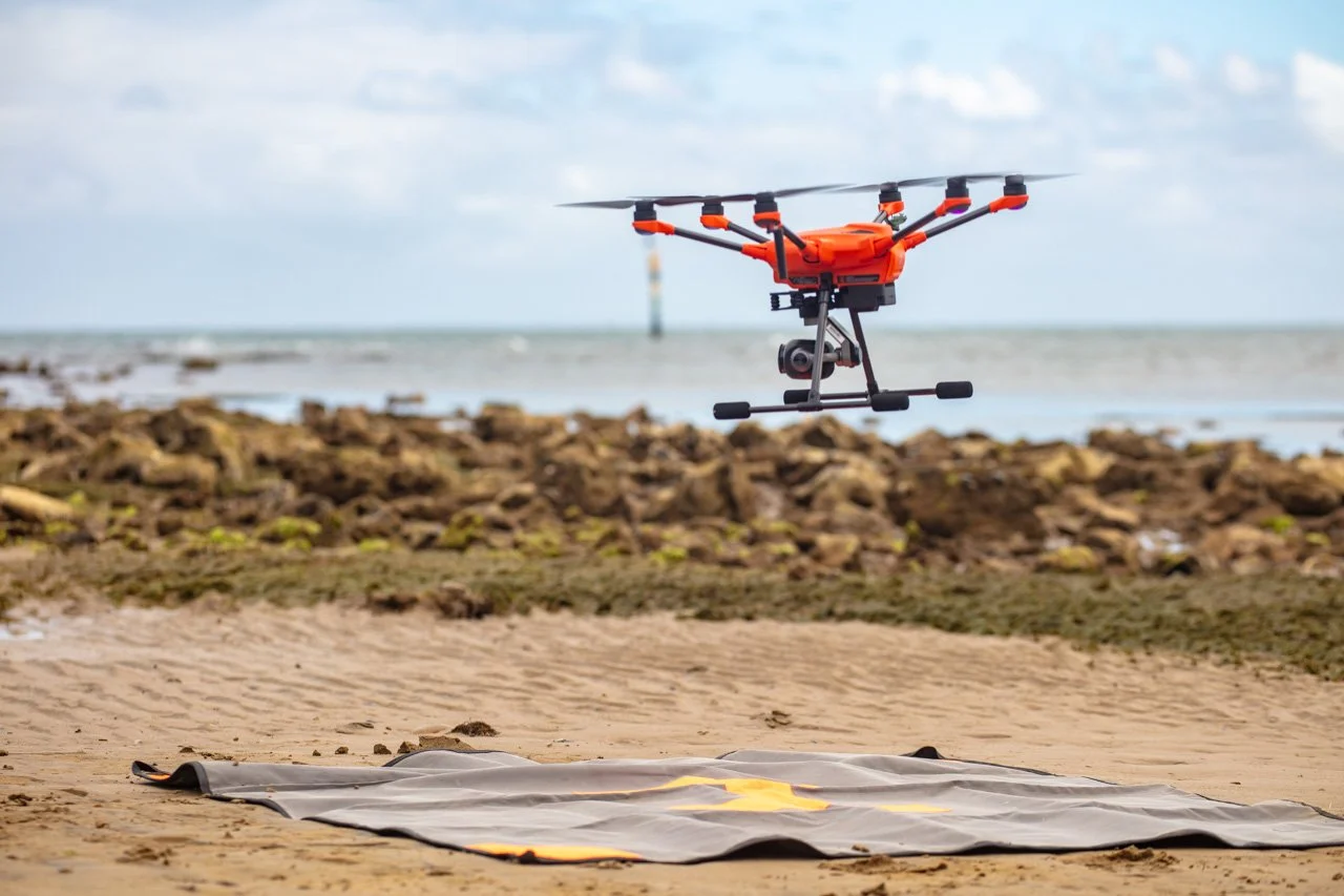
The drone flies autonomously covering the whole area so each image overlaps.

The resulting image is ground-truthed and can identify specific marine communities.
Underwater
We also have underwater drones that can do the same. These will map either visually, using images like the aerial drones, or using LIDAR (like radar). They can also count fish and do other interesting things. Our intention is to baseline map our pilot study area this year.
Baseline work is essential. Where and how often we repeat this, might be something you help us to decide. Again, this depends on socially-led priorities.
We will design these surveys based on your input and needs. This is not science for its own sake, or experimental research for our sake. This is a practical application, for our community to answer questions that help us make decisions about how to protect our lifestyles and livelihoods into the future.
This design process begins once we have our model finalised and represents the next exciting step in building a community-owned decision support tool.
Find out more
If you haven’t done already, sign up on the website … and join one of our workshops.